Ura-Bandai area [裏磐梯]
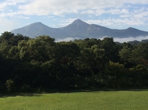
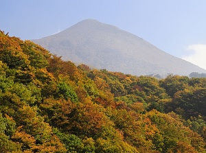
Mt.Bandai from Ura-Bandai area
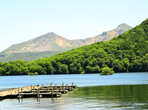
Mt.Bandai from Goshikinuma
Ura-Bandai is the northern area of Mount Bandai (1,816 m).
It is a highland 700 to 1,000 meters high.
It is also called Bandai-kogen (Bandai Highland).
There are Azuma Mountains (around 2,000 meters) about 10 km north of Mount Bandai, and there is Mount Adatara (1,728 m) about 20 km wast of Mount Bandai.
Ura-Bandai area is a highland surrounded with these mountains.
In 1888, Mount Bandai had occured the great eruption since 806.
The northern part of the top collapsed on a large scale.
Then, massive earth and rocks flew down to the northern direction at speeds of over 80 kilometers per hour.
The earth and rocks destroyed three villages at the foot the mountain.
477 people had been killed or missed.
Additionally, the earth and rocks blocked many rivers, then Lake Hibara, Lake Akimoto, Lake Onogawa and other many small lakes had been formed.
During subsequent a few decades, here had been a barren land.
In the 1910s, Endo Genmu (1864-1935), a merchant in Aizu-Wakamatsu city, planted 100 thousand trees with his hands on such land at his own expense.
Now the trees have grown big because over a century has passed since that.
Therefore, Ura-Bandai area is covered with rich forests and is designated a part of Bandai-Asahi National Park since 1950.
Some scenic roads are set up in this area.
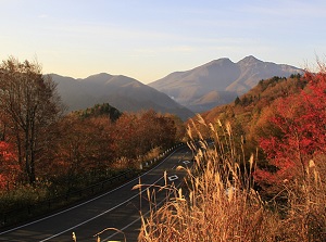
Bandaisan Gold Line (磐梯山ゴールドライン)
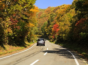
Bandaisan Gold Line
Photo by Fukushima Prefecture
Scenery from Bandaisan Gold Line
Photo by Fukushima Prefecture
Bandaisan Gold Line is a toll road which runs through the western side of Mount Bandai and reaches to southen area of Ura-Bandai.
The total length is about 18 km.
The entrance of the road is located about 10 km west of Inawashiro station.
On the way, there are some observatories by the road.
Especially, Happodai (八方台) is the main observatory at the highest point of this road.
There is the starting point for a climb to Mount Bandai at this observatory.
And the walking trails to Lake Oguninuma starts from here.
Goshikinuma (五色沼)
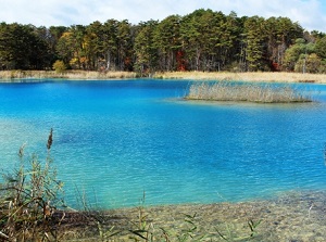
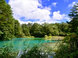
Goshikinuma is a cluster of small lakes formed by being blocked the rivers after the eruption of Mount Bandai in 1888.
It is the most popular spot in Ura-Bandai, and most tourists visit here.
It is located about 1 km east of the exit of Bandaisan Gold Line, and is near the southernmost coast of Lake Hibara.
There are about 40 small lakes in this area.
A walking trail about 3.6 km long is set up, and we can visit about 10 lakes of them along the trail.
"Goshikinuma" means "five colored lakes".
Surely the color of each lake is different.
The colors are emerald green, cobalt blue, copper red and so on.
So we can enjoy the various views of the lakes.
At the entrance of the walking trail, there is Ura-Bandai Visitor Center.
Museum of the Mount Bandai Eruption (磐梯山噴火記念館)
Museum of the Mount Bandai Eruption is a museum introducing the eruption of Mount Bandai in 1888.
It is located about 2 km northeast of Ura-Bandai Visitor Center.
It was established in 1988 to commemorate the 100th anniversary of the eruption.
The history of Mount Bandai and the scene of the eruption are explained with models and screen images.
Lake Hibara (桧原湖)
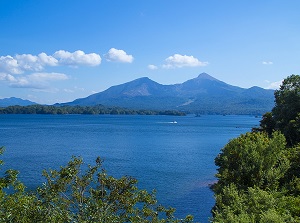
Lake Hibara and Mt.Bandai
Photo by Fukushima Prefecture
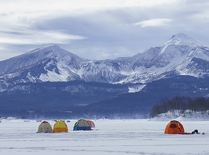
Lake Hibara in winter
Photo by Fukushima Prefecture
Lake Hibara is the largest lake in Ura-Bandai area.
It spreads to the north near Goshikinuma.
It is about 9 km long from north to south but the width from east to west is within 2 km.
A road is set up around this lake, and there are several walking trails and camp sites.
This lake freezes in winter, so we can enjoy the smelt fishing on the freezed lake.
The pleasure boat is operated.
The boarding point is near Ura-Bandai Visitor Center.
The regular sightseeing bus rounding the lake is operated 2 to 4 times a day on the weekend from late April to early November.
The nickname of the bus is "Mori-no-Kumasan" ("Bear in a forest" in English).
The body of the bus is old style made in 1967, but it runs on the fuel made from used cooking oil from home and restaurants.
It is an eco-friendly vehicle.
Lake Onogawa
Photo by Fukushima Prefecture
Lake Akimoto
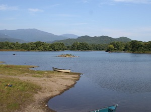
Lake Onogawa (小野川湖)
Lake Onogawa is a lake located about 2 km east of Lake Hibara.
It is also a slender lake, and the length is about 3.5 km.
We can enjoy fishing and canoeing in summer, and we can enjoy the smelt fishing on the freezed lake in winter.
Lake Akimoto (秋元湖)
Lake Akimoto is a lake located about 4 km east of Lake Hibara.
It is also a slender lake, and the length is about 5 km.
We can enjoy various outdoor sports around this lake.
Here is a good photo shoot spot of sunrise, then photographers often visit here.
Bandai-Azuma Lake Line
Photo by Fukushima Prefecture
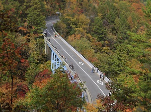
Nakatsugawa Gorge
Photo by Fukushima Prefecture
Bandai-Azuma Lake Line (磐梯吾妻レークライン)
Bandai-Azuma Lake Line is a toll road which runs along Lake Akimoto and Lake Onogawa.
The total length is about 13 km.
The entrance is located about 1 km east of Lake Akimoto and the exit is near the westernmost edge of Lake Onogawa.
On the way, there are a few observatories by the road.
Nakatsugawa Gorge (中津川渓谷)
Nakatsugawa Gorge is a gorge formed by Nakatsugawa River flowing into Lake Akimoto, and is located just north of Lake Akimoto.
Bandai-Azuma Lake Line crosses over here at the level of over 50 meters.
We can come down to this gorge from the parking by the road.
It is famous for the beautiful colored leaves in autumn.
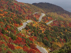
Bandai-Azuma Sky Line
Photo by Fukushima Prefecture
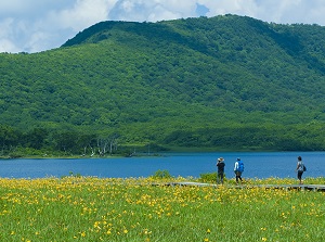
Lake Oguninuma
Photo by Fukushima Prefecture
Bandai-Azuma Sky Line (磐梯吾妻スカイライン)
Bandai-Azuma Sky Line is a toll road which runs through the eastern part of Azuma Mountains.
It is located at the eastern edge of Ura-Bandai area, and is away from main spots of Ura-Bandai.
But it is one of the routes from Fukushima city, and has some scenic points along this road.
The entrance is located about 14 km west of Fukushima city and the exit is located about 9 km east of Lake Akimoto.
The total length is about 29 km.
Lake Oguninuma (雄国沼)
Lake Oguninuma is a caldera lake located about 6 km southwest of Lake Hibara, and is at the level of about 1,000 meters.
Around this lake, we can see many alpine plants.
Especially the great daylily community is beautiful in June and July.
To visit here, there are some routes.
But all parkings for cars and buses are set up away from here.
The closest parking is on Kanazawa pass located 1 km west of the lake, and here is a distance of about 12 km from Kitakata city.
It takes about 30 minutes on foot from the parking to the lake.
But the car traffic is limitted in the season of daylily.
From Happodai parking of Bandaisan Gold Line, it takes about 2 hours and 30 minutes on foot.
How to get here
From Kooriyama to Inawashiro, about 35 minutes by rapid train of JR Ban-etsu West Line.
From Inawashiro station, by route bus, 24 minutes to Ura-Bandai Visitor Center (The entrance of Goshikinuma lakes).
This bus runs through not Bandaisan Gold Line but a local road.
From Kitakata station, by route bus, about 1 hour to Ura-Bandai Visitor Center.