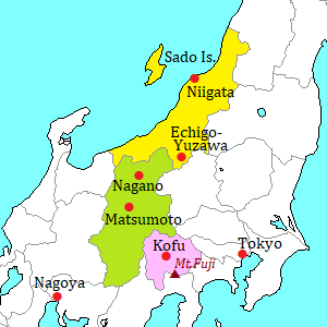
Sado Island [佐渡島]
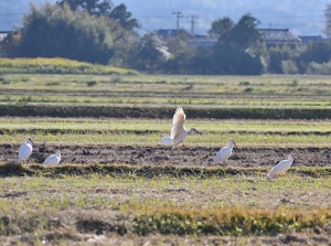
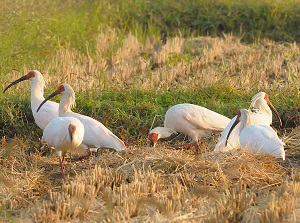
Toki in rice field in Sado
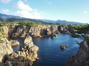
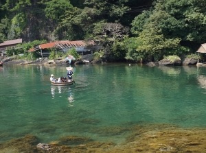
Senkaku Bay in Sado
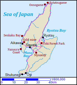
Sado Island is an island located about 45 km west of Niigata city.
In Japanese, it is generally called "Sadogashima", or simply "Sado".
The island is about 30 km from east to west and about 60 km north to south in width.
The northwestern part and southeastern part of the island are mountain ranges, and the center part between them is a plain.
A few million ago, two islands were formed, sand and rocks were carried and deposited by the rivers between the islands, then the islands were connected.
That is how current Sado Island has been formed.
The northeastern side of the island is Ryôtsu Bay, and the southwestern bay is called Mano Bay.
From both mountain ranges, many rivers flows down into the central plain.
So 80% of the people in the island live and rice is cultivated in the plain.
Sado Island had been a place of exile since ancient times.
Over a long period of history, even an Emperor, nobilities from Kyoto, warlords, high priests were exiled here politically.
Therefore, Sado has an unique culture mixed with aristocratic culture, samurai culture and popular culture.
So this island has the unique and traditional Noh, Joruri (puppet ballad-drama), lion dance and the other performing arts.
On the other hand, a great gold vein was found in this island in 1601.
Since that, it became the largest gold and silver mine in Japan, so this island were governed by Edo Government until 1868.
The operation of the mine ended in 1989.
But Sado has still an image of gold mine.
Tarai-bune in Sado
Yajima and Kyojima in Sado
To Sado Island, the high-speed ship or ferry is operated from Niigata Port.
They come into Ryôtsu Port in Ryôtsu Bay.
There is no airline to Sado Island now.
(There is an airport but it has no passenger service.)
And there is no railroad in the island.
So the public transportation is only the route bus, and you can visit most spots by bus.
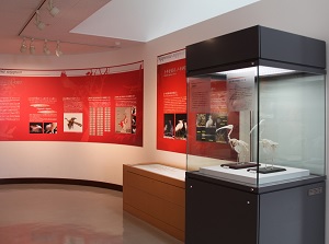
Toki Forest Park (トキの森公園)
Museum in Toki Forest Park
Photo by Sado Kankou PHOTO
Toki
Photo by Sado Kankou PHOTO
Toki Forest Park is a park about "Toki" (Japanese crested ibis).
It is located about 7 km south of Ryotsu Port.
Toki is the bird living in East Asia, and the scientific name is "Nipponia Nippon".
("Nippon" means "Japan".)
In the 20th century, excessive hunting and deforestation led to their drastic decline.
Around 1970, the Japanese government began trying to breed them by borrowing some tokis from China. (In China, over 1,000 tokis are living.)
After the last purely Japanese toki was dead in 2003, all tokis remaining in Japan has been from China.
There is Crested Ibis Conservation Center in Toki Forest Park.
Now, about 70 tokis are bred in this park.
We can see the breeding tokis here. And there is a museum about toki.
In addition, over 500 released tokis from the facility are living in Sado Island.
By route bus (Minami Line), about 20 minutes from Ryotsu Port.
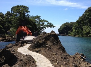
Myôsenji temple (妙宣寺)
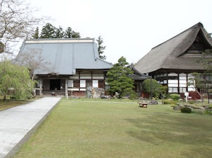
Myosenji
Photo by Railstation.net
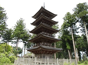
Five-story pagoda of Myosenji
Photo by Railstation.net
Myôsenji is a Buddhist temple located in Mano distict near Mano Bay.
It is located about 17 km southwest of Ryotsu Port.
It is the temple of Nichiren Buddhism, one of the major schools in Japan, and was founded in 1221.
The five-story pagoda in this temple is the only one in Niigata Prefecture.
The height is about 24 meters.
It is said that it was built with modelling the five-story pagoda in Nikko Toshogu shrine and was completed in 1825 after about 30 years' work.
By route bus (Minami Line), get off at Takedabashi stop.
About 35 minutes from Ryotsu Port. Then about 1 km on foot.
Aikawa town (相川)
Aikawa is the town on the west coast and is about 25 km west-southwest of Ryutsu port.
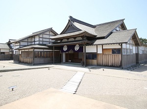
Restored Sado Bugyosho
Photo by Railstation.net
Court of law in Sado Bugyosho
Photo by Railstation.net
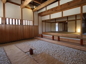
After the gold mine was found, Sado magistrate's office (Sado Bugyosho) (佐渡奉行所跡) was established in this town.
So this town had been the center of Sado Island.
Sado Bugyosho is north of the center of the town and was used from 1601 to 1868.
It had been managed by Edo Government, and performed the management of gold mine, manufacture of gold and silver, and judgement of trouble and accident in the town.
Current buildings were restored in 2000.
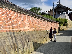
Brick wall along Kyomachi Street
Photo by Sado Kankou PHOTO
Old house in Kyomachi Street
Photo by Sado Kankou PHOTO
From there, narrow Kyômachi Street (京町通り) runs to the east.
It was the main street from Aikawa to the gold mine.
There is Former Aikawa Detention House (旧相川拘置支所) used from 1954 to 1972 at the east end of the street.
It is open to the public as a nation's registered tangible cultural property.
Kitazawa Flotation Plant
Photo by Railstation.net
Kitazawa Flotation Plant
Photo by Railstation.net
To the north of Sado Bugyosho, there is Kitazawa Flotation Plant (北沢浮選鉱場跡).
It was a plant to extract ores from the gold mine and was used from 1937 to 1952.
It seems to ancient ruins and some says that it is like a ruin in a popular Japanese animated film "Castle in the Sky" by Studio Ghibli.
To Aikawa town, it takes about an hour from Ryotsu port by route bus.
Sado gold mine (佐渡金山)
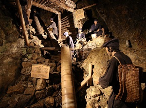
Workers in Sado gold mine in Edo Period
Photo by Railstation.net
Mountain with huge gap
Photo by Railstation.net
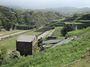
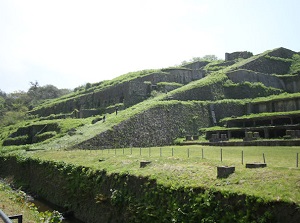
Sado gold mine is the ruin of gold mine located about 2 km east of Aikawa town.
It was designated as World Cultural Heritage Site in 2024.
In 1601, a great gold vein was found in this mountain.
Since that, it became the largest gold and silver mine in Japan.
There is a mountain with huge gap.
It is the ruin of open-cut mining and is a symbol of the gold mine.
The gold mine was controlled by the goverment and the gold contributed to the finance of the country.
Because of exhaustion of vein of gold, the mining has been closed down in 1989.
The total length of the tunnels is over 400 km, and a section about 300 meters long is opened for visitors.
Some guided tours are provided for the visitors.
From Aikawa town to the mine, it takes about 10 minutes by route bus.
Ogi district (小木)
Tarai-bune of Ogi Port
Photo by Sado Kankou PHOTO
Yajima and Kyojima
Photo by Sado Kankou PHOTO
Ogi is a district located near the southwestern tip of the island.
It has a port, and the ferry comes from Naoetsu city.
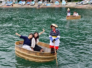
In this district, Tarai-bune (tub boat) is famous.
Tarai-bune is made of wood, and the diameter is about 1.4 to 1.8 meters and the depth is 55 centimeters.
It has been used to gather the shells or seaweeds around reefs.
At Ogi Port, we tourists can experience to board.
It is unstable and thrilling a little.
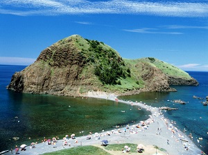
And there are Yajima (矢島) and Kyôjima (経島) about 2 km southwest of Ogi Port.
There are small rocky islands by the coast, and the coast is a scenic spot.
We can experience Tarai-bune here.
By route bus (Ogi Line), from Sawata near to Ogi, about an hour.
(Sawata is a bus terminal on the line between Ryotsu Port and Aikawa.)
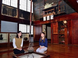
Shukunegi district (宿根木)
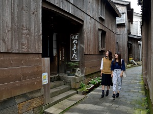
Street in Shukunegi
Photo by Sado Kankou PHOTO
A house in Shukunegi
Photo by Sado Kankou PHOTO
Shukunegi is a small district located about 4 km west of Ogi.
It faces a small inlet, and the ships of Sea of Japan route called at this district in Edo Period (1603-1868).
So many houses were built.
Now there are over 100 old wooden houses in the narrow area.
Most of them are built by shipwrights, so they are a little unique.
By route bus (Shukunegi Line), from Ogi to Shukunegi, about 12 minutes.
Scenic spots of the northwestern coast
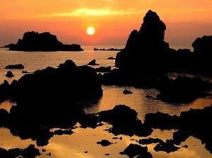
Sunset at Nanaura Coast
Photo by Niigata Prefectural Tourist Association
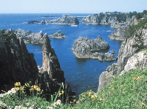
Senkaku Bay
Photo by Niigata Prefectural Tourist Association
Nanaura Coast (七浦海岸) is the coast about 10 km long from the south of Aikawa town.
The scenery of sunset is beautiful, and Meotoiwa (夫婦岩) that two big rocks stand is the popular spot.
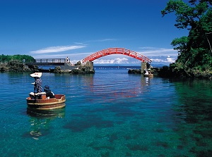
Senkaku Bay (尖閣湾) is located about 5 km north of Aikawa town.
We can see the high cliffs, various rocks and clear sea water.
It is thought that the rocks around the bay were formed by coral reef several million years ago.
We can enjoy the scenery along the walking trail on the cliffs, and tour by pleasure boat.
Oonogame
Photo by Niigata Prefectural Tourist Association
Futatsugame
Photo by Niigata Prefectural Tourist Association
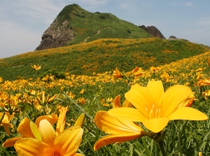
Oonogame rock (大野亀) is a huge monolith located near the northernmost of Sado Island.
It looks like a cape of rock, and the height is 167 meters.
Around here, many daylilies grow naturally.
And Futatsugame (二ツ亀) is a rocky island located 2.5 km northeast of Oonogame.
The water around the sea is very clear.
At low tide, a sand bank connects Futatsugame and the main land.
How to get here
From Niigata Port to Ryotsu port, 1 hour by high-speed ship, 2 hours and 20 minutes by ferry.