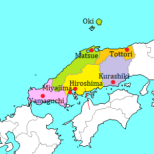
Oki Islands [隠岐]
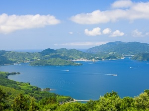
Scenery of Oki Islands
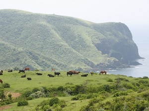
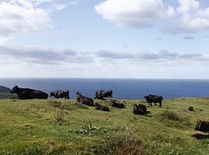
Pasture in Oki Islands
Oki Islands are the islands located about 70 to 100 km north of Shimane Peninsula in the Sea of Japan.
In Japanese, these islands are called "Okinoshima" or simply "Oki".
On the northeast side, there is nearly circular Dôgo island (島後).
On the southwest side, there are Dôzen islands (島前) consisting of main three islands.
They are Nakanoshima island (中ノ島), Nishinoshima island (西ノ島) and Chiburijima island (知夫里島).
Nakanoshima is often called as Ama (海士) from the town name, and Chiburijima is also called as Chibu (知夫) from the village name.
The shortest distance between Dôgo and Dôzen is about 13 km.
People were already lived in these islands in the Stone Age (thousands years ago).
Around the 7th century, a local government was set up in Oki.
In the middle ages, Oki became a place of exile.
Especially the exile of Emperor Go-Toba in 1221 and the exile of Emperor Go-Daigo in 1332 are known as the important events in the history.
And in the 18th century, Oki became a port waiting for a good wind to sail on the ship course connecting western Japan and northern Japan.
Tamawakasu-mikoto Shrine in Dogo island
Rosoku-jima in Dogo island
Oki Islands were formed by volcanic activity about 5 million years ago.
So the islands are hilly and there is no flat land.
Whole area of Oki has been designated as a part of the National Park.
The main sightseeing spots in Oki islands are the sceneries of its rich nature.
To Oki Islands, there are the air routes from Izumo Airport and Itami Airport (Osaka).
Oki Airport is at the south end of Dôgo island.
It is a little hard to tour around the island.
Route buses run only in Dougo Island, but there are only a few services a day on each route.
So you only have a choice of the means of transportation such as rental car, rental bicycle, walking.
Dôgo island (島後)
Tamawakasu-mikoto Shrine
Photo by Shimane Prefecture
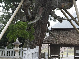
Yaosugi in Tamawakasu-mikoto Shrine
Photo by Shimane Prefecture
Dôgo is nearly circular island and the diameter is about 18 kilometers.
The whole area is hilly, but the highst place is about 600 meters high.
There is Saigo (西郷) district on the southeast coast of the island.
It is the main town and there are a ferry port and an airport.
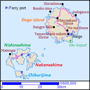
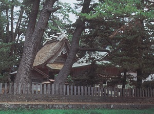
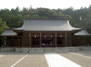
Tamawakasu-mikoto Shrine (玉若酢命神社) is a Shinto shrine located about 2.5 km west of Saigo Port.
It was unknown when the shrine was founded, but a document in the late 9th century had descriptions of the shrine.
Some buildings in the precinct were built around the middle of the 19th century, and are designated as national important cultural properties.
Yaosugi (八百杉) in the precinct is a big Japanese cedar tree and is over 1,000 years old.
It is designated as a natural monument in Japan.
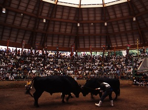
By the way, "Ushi-tsuki" is the exciting event in Oki Islands, and is a Japanese bullfighting.
Unlike Spanish bullfighting, Ushi-tsuki is the match between two bulls.
It has about 800 years of tradition.
Real matches are held at a few bullrings in the island three times a year.
For tourist, the performance is seen at Mô-mô Dome.
It is a bullring with dome roof and is located about 2.5 km north of Tamawakasu-mikoto Shrine.
It is held several times a month but the schedule is irregular.
Mo-mo Dome
Photo by Shimane Prefecture
Mizuwakasu Shrine
Photo by Shimane Prefecture
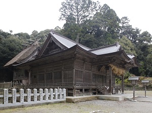
Mizuwakasu Shrine (水若酢神社) is is a Shinto shrine located about 11 km northwest of Tamawakasu-mikoto Shrine.
It is regarded as the foundation in the 4th century.
It is also unknown, but it exited in the 9th century.
The main shrine was built in 1795 and has a thatched roof.
It is designated as a national important cultural property.
Rosoku-jima
Photo by Shimane Prefecture
Shirashima Coast
Photo by Shimane Prefecture
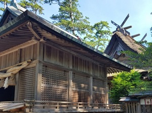
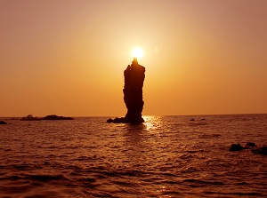
Rôsoku-jima (ローソク島) is the most popular spot in Dôgo island.
It is located near the northwest coast of the island.
In English, it means "Candle island".
A rock about 20 meters high stands about 500 meters off the coast, and it resembles a candle.
When the setting sun comes just at the pointed top the rock, it looks like a lighted candle.
The observatory to see the rock is set up on the coast.
And the pleasure boat to see the sunset scene is operated from the pier in Omosu Port (重栖港) about 4 km southwest of the rock. (You need to make a reservation in advance.)
Shirashima Coast (白島海岸) is the coast around the northern cape of the island.
Around the cape, many small rocky islands are dotted.
The color of the rocks in the north side is white and the rocks in the east side are black.
There is an observatory near the cape.
Jodogaura Coast
Photo by Shimane Prefecture
Behind Dangyo Falls
Photo by Shimane Prefecture
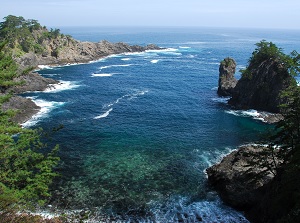
Jodogaura Coast (浄土ヶ浦海岸) is a coast with many rocks and steep cliffs in the northeast part of the island.
It is most beautiful coast in the island.
Various kinds of rocks and plants are seen, and the water of the sea is clear.
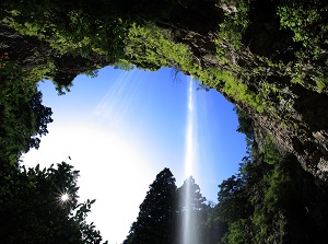
Dangyo Falls (壇鏡の滝) is located in the mountain in the west part of the island.
It is a waterfall about 50 meters high, and is the largest waterfall in Oki Islands.
We can go behind the waterfalls.
There is Dangyo Shrine near the waterfall, and the people in the island think that the water leads to the long life.
Nakanoshima island (中ノ島) [Ama town (海士町)]
Oki Shrine in spring
Photo by Shimane Prefecture
Main shrine of Oki Shrine
Photo by Shimane Prefecture
There is Hishiura Port on the northwest coast of Nakanoshima island.
It is about 30 km from Dôgo island, and it takes 1 hour and 10 minutes by ferry.
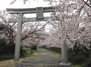
There is Oki Shrine (隠岐神社) about 3 km east of Hishiura Port.
It is a Shinto Shrine and Emperor Go-Toba (1180-1239) is enshrined.
Exiled Emperor Go-Toba died in this island in 1239.
After that, small tomb was built.
A mausoleum was built in 1658, but it was demolished in 1869.
This shrine was finally built to mark the 700th anniversary of the Emperor's death in 1939.
About 250 cherry trees are planted along the approach, and here is the best cherry blossom viewing spot in Oki Islands.
Nishinoshima island (西ノ島)
Kuniga Coast
Photo by Shimane Prefecture
Matengai in Kuniga Coast
Photo by Shimane Prefecture
There is Beppu Port on the east coast of Nishinoshima island.
It is about 3.5 km from Hishiura port in Nakanoshima, and it takes 15 minutes by ferry.
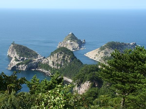
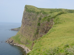
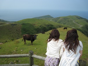
Kuniga Coast (国賀海岸) is the attractive spot in this island, and is located about 9 km west of Beppu Port.
Steep cliffs are along about 13 km of coast and the height is over 200 meters.
And grass fields spread on the gentle slope on the cliffs.
Matengai cliff (摩天崖) is 257 meters high, and there are several caves along the coast.
There is a ruin of observation post of the old Japanese army in World War II on the cliff.
The route bus is operated a few times a day to the coast, and a walking trail about 1 km long is set up to Matengai.
Chiburijima island (知夫里島) [Chibu village (知夫村)]
Akahageyama in Chiburijima
Photo by Shimane Prefecture
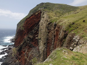
Chibu-Sekiheki
Photo by Shimane Prefecture
There is Kurii Port on the northeast coast of Chiburijima island.
It is about 10 km from Beppu port in Nishinoshima, and it takes 30 minutes by ferry.
Akahageyama mountain (赤ハゲ山, 325 m) is located about 3 km west of Kurii Port, and it is a good observatory of the island.
Chibu-Sekiheki (知夫赤壁) is the coast about 1 km long with rusty steep cliffs and is at the southwest part of the island.
"Sekiheki" means "Red walls", and the colored cliffs have a strong impact.
We can see them from an observatory, and the pleasure boat is operated.
How to get here
To Oki Islands, there are the air routes from Izumo Airport and Itami Airport (Osaka).
Oki Airport is at the south end of Dôgo island.
It takes 30 minutes fom Izumo Airport and 50 minutes from Itami Airport.
Or, ferries are operated from two ports (Shichirui, Sakaiminato) in Shimane Peninsula.
Dôgo Island (Saigo Port) is the first destination, then the ferry visit the other islands.
It takes about 70 minutes by jet ferry, about 2.5 hours by ordinary ferry from the mainland.