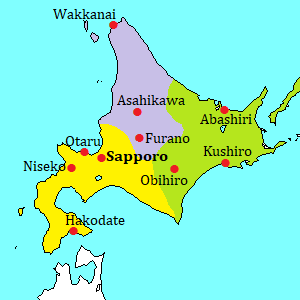
Biei town [美瑛]
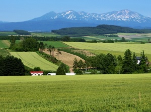
Scenery of Biei
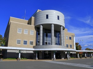
Information center, Shiki-no-Tou
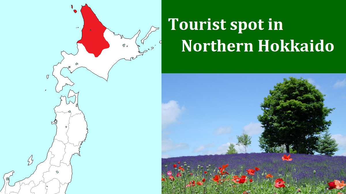
Biei is a small town located 25 km south-southeast of Asahikawa city.
It is well-known as a town with many picturesque beautiful hills and un-Japanese landscape.
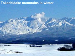
In the east side of the town, there are Mount Tokachidake (2,077 m) and some mountains.
They are active volcanoes.
This town is originally a volcanic ash land by the volcanoes.
Since 1900, the farmers have been plowed this poor land and planted potato, wheat, sugar beet and other vegetables.
In 1971, Shinzo Maeda (1922-1998), a landscape photographer, saw this landscape by chance and was very impressed.
Then he introduced this area on his photo books.
After that, since the 1980s, young travelers got to visit here.
Then Biei had became one of the most popular spots in Hokkaido in the 1990s.
The center of the town is around JR Biei station and there are shops and restaurants.
The northwestern scenic area of the station is named as Road of patchwork, and the southern scenic area is named as Panoramic road.
Additionally, a route from Biei station to the foot of Tokachidake volcano is named as Refresh line.
There is the information center named as Shiki-no-tou (四季の塔, "Tower of the four seasons" in English).
It is added to the town office located about 500 meters southeast of JR Biei station.
You can get the maps of the areas and other information there.
And you can see the scenery around Biei at the observatory in the 32-meter-high tower.
Caution!
Most scenic points are in the farm of common farmers.
Recently, many tourists troubles the farmers.
The tourists often enter the cultivated land without permission.
Even if they are warned by the farmer, some of them don't listen to him.
It is the same thing that wild animals damage the farms.
Please don't disturb the farmers in their work.
And please don't enter any field and meadow.
Road of patchwork
It is a route to the north of Biei station.
The sightseeing spots are at No.1 to 6 in the map.
To avoid repeat cultivation, different crops are planted in each piece of fields.
So we can see the landscape of the hills like a patchwork.
In the field, trees and flowers are dotted.
In summer, we can see the colorful and picturesque scenery.
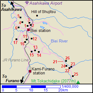
- (1) Northwestern hill observatory Park (北西の丘展望公園)
It is located 2 km north of Biei station.
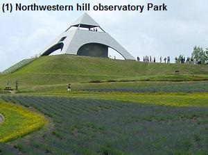
It is on a top of a gently sloping hill, and there is an observatory like a pyramid. - (2) Hill of Zerubu (ぜるぶの丘)
It is located 2.5 km northeast of Biei station and on the Route 237.
This is a new observatory which young men in this town built in 1998.
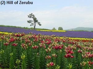
- (3) Tree of Ken and Mary (ケンとメリーの木)
It is located 2.5 km north of Biei station.
It is a solitary poplar."Ken and Mary" is the words in the commercial song for a car of Nissan in 1972, then this landscape was used in the TV commercial.
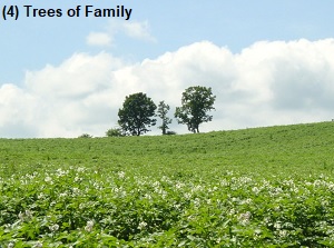
- (4) Trees of Family (家族の木)
It is located 4 km northwest of Biei station.
There are three oak trees standing like a family on a hill.
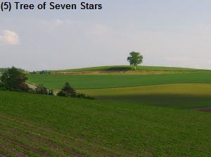
- (5) Tree of Seven Stars (セブンスターの木)
It is located 6 km northwest of Biei station.
It is a solitary oak.In 1976, this landscape was used the commercial of a Japanese cigarette "Seven Stars".
Around here, we can see the landscape of "patchwork".
Unfortunately, some birch trees had been cut down by the owner in January of 2025.
Many foreign tourists had ignored the manner that they must not enter the owner's vegetable field and took the selfish behavior. - (6) Hill of Mild Seven (マイルドセブンの丘)
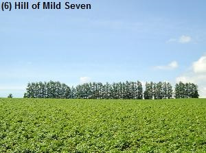
It is located 4 km west of Biei station.
Some larches stand in line on the hill.In 1977, this landscape was used the commercial of a Japanese cigarette "Mild Seven".
But the scene of the photo is not seen. The trees had been cut down by the owner in 2018.
The reason is the same as the other places.
Panoramic road
It is a route to the south of Biei station.
The sightseeing spots are at No.11 to 17 in the map.
This area is wider than "Road of patchwork".
It is on the gentle slope of the foot of Tokachidake volcano, so we feel open.
The scenery is also similar to the places in Road of patchwork.
In these spots of Panoramic road, the view of Tokachidake is added.
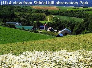
- (11) Shin'ei hill observatory Park (新栄の丘展望公園)
It is located 5 km south of Biei station.
It is on a top of a hill, and has a good view.Many tourist visit here, so it is always crowded.
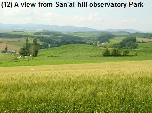
- (12) San'ai hill observatory Park (三愛の丘展望公園)
It is located 1.5 km east of Shin'ei hill.
It is nearer to Tokachidake mountains than Shin'ei hill.
So we can see the view more grandly.
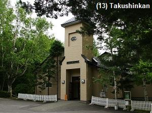
- (13) Takushinkan (拓真館)
It is located 8 km south-southeast of Biei station.
It is a famous photo gallery opened by Shinzo Maeda in 1987.
His main works are exhibited. - (14) Tree of Philosophy (哲学の木)
It is located 2 km east of Takushinkan.
A solitary big tree had stood at the center of wide field.It looked like "thinking tree" and was one of popular spots.
But, it is already not there.Unfortunately, this tree had been cut down by the owner in February of 2016.
Because, it had become very old.But, the biggest reason was that many tourists had ignored the manner that they must not enter the owner's vegetable field.
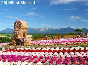
- (15) Hill of Shikisai (四季彩の丘)
It is located 8 km south of Biei station.
It has a good view, and there is extensive flower field around here.
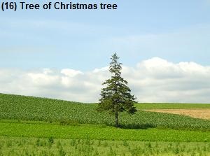
- (16) Tree of Christmas tree (クリスマスツリーの木)
It is located 1 km southwest of Shin'ei hill.
A spruce tree stands at the center of wide field.It looks like a Christmas tree.
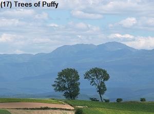
- (17) Trees of Puffy (パフィーの木)
It is located 4 km west of Shin'ei hill.
There are two poplars."Puffy" is the Japanese pop rock band of two girls.
A drama starring them was shot here in 1997.
Refresh line
A road about 20 km long runs from the central area of Biei to Shirogane Onsen area at the foot of Tokachidake volcano.
There are some spots around Shirogane Onsen.
These are the views in the mountain.
The sightseeing spots are at No.21 to 26 in the map.
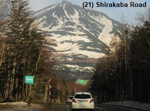
- (21) Shirakaba Road (白樺街道)
Shirakaba means white birch.
Many white birches have grown naturally on the mudflow by Tokachidake volcano eruption in 1925.We can see them along the road for 4 km long to Shirogane hot spring resort.
Now they are naturally changing to pine tree and so on.
- (22) Shirogane hot spring resort (白金温泉)
It is located 22 km southeast of Biei station and is just at the foot of Tokachidake volcano.
There are a few hotels along the gorge where the Biei river flows.By route bus, it takes 26 minutes from Biei station.
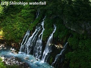
- (23) Shirohige waterfall (白ひげの滝)
It is a waterfall located just north of Shirogane hot spring resort.
From the middle of a cliff, ground water falls down into the stream.
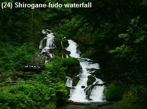
The color of water is clear. - (24) Shirogane-fudo waterfall (白金不動の滝)
It is a waterfall located 1 km northwest of Shirogane hot spring resort.
Cold water fall down on the rocks like stairs.
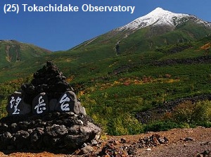
- (25) Mount Tokachidake Observatory (十勝岳望岳台)
It is located 4 km south of Shirogane hot spring resort.
It is at a height of 930 meters, and is called "Bougakudai" in Japanese.
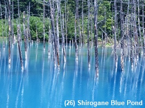
The Tokachidake volcano is outspread before us. - (26) Shirogane Blue Pond (白金青い池)
It is located 3 km northwest of Shirogane hot spring resort.
It was made naturally after construction of a dam to control mudslides from the volcano by 1997.The color of the water is beautiful blue and the withered trees are nice.
How to get here
By local train of JR Furano line, it takes about 35 minutes from Asahikawa.
By route bus, It takes 50 minutes from JR Asahikawa station to Biei station.
And, from Asahikawa Aoirport to Biei Station, it takes 16 minutes.