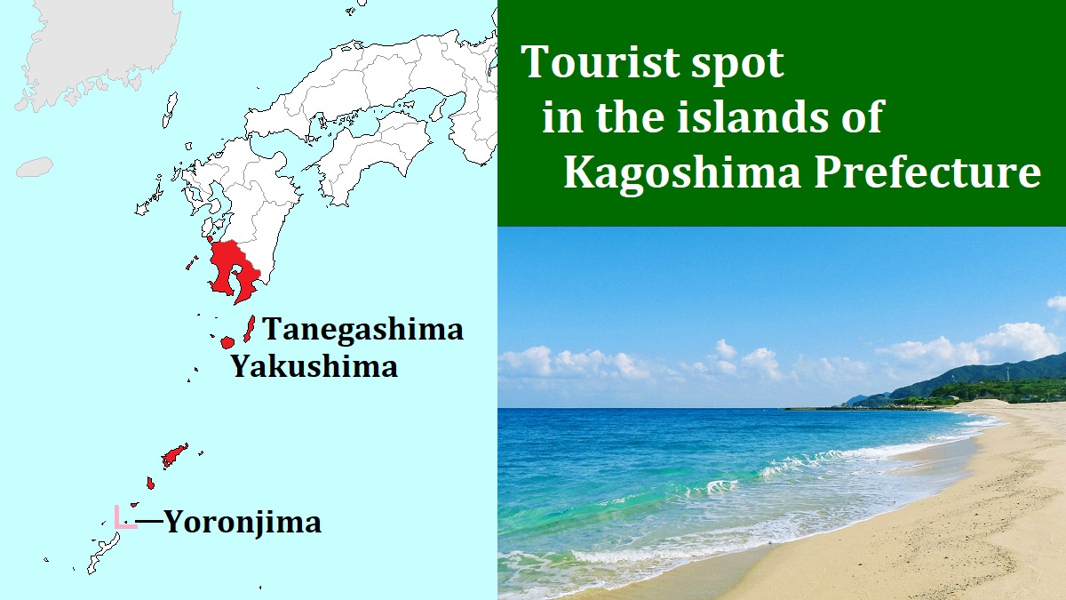
Yakushima island [屋久島]
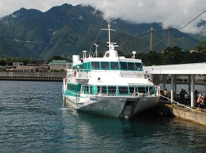
Miyanoura Port in Yakushima
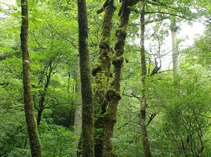
Yakusugi Land in Yakushima
Yakushima is an island located about 70 km south of Kyushu Island.
The distance from Kagoshima city to Yakushima is about 140 km by ship.
The shape of the island is roughly rounded pentagon.
It is about 28 km from east to west and about 26 km from north to south.
This island is sort of a steep large mountain towering in the ocean.
Many peaks more than 1,000 meters high cover this small island.
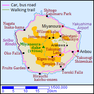
The highest peak is Miyanouradake (宮之浦岳, 1,936 m) in the center of the island.
Because the wet air from the sea hits these steep mountains directly all through the year, so the coast area has over 4,000 millimeters of rainfall annually and the mountain area has over 10,000 millimeters.
The much rain has grown the rich forests in whole island.
The island is in subtropical zone.
We can see the subtropical plants around the coast area, but the mountain area has the wide forest in the temperate zone.
Around the peak of the mountains, there area the forests in a subarctic zone.
The annual mean temperature is around 20 degrees C in the coast area, but it is about 5 degrees C on the top of the mountain.
Because of the rich and diverse nature, one-fifth part of the island is designated as a World Natural Heritage site.
Mount Miyanouradake in Yakushima
Shiratani-Unsuikyo in Yakushima
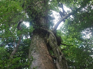
In the area higher than 500 meters, Yakusugi (屋久杉) grow naturally.
Yakusugi is a kind of Japanese cedar and is a species endemic to Yakushima.
The lifespan of general Japanese cedar is about 500 years.
But the lifespan of Yakusugi is very long, and the trees over 2,000 years old are quite common.
We can see such trees living for an immeasurable time in this island.
We may see wild monkeys and deer in the forest.
Strangely, this island doesn't have so various animals.
Miyanoura village and port
Photo: Kyushu Tourism Promotion Organization
Entrance of Yakusugi Land
Photo: Kyushu Tourism Promotion Organization
Some small villages are dotted along the coast, and a road is set up around the island to connect the villages.
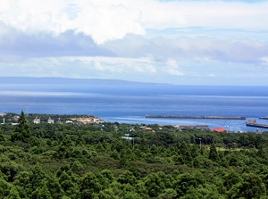
Miyanoura (宮之浦) on the north coast is the largest village.
About 3,000 people live in the village and the number is one forth of the people in Yakushima.
Miyanoura district has the main port of the island.
The ships from Kagoshima city enter this port.
Anbou (安房) on the east coast is the second largest village.
Yakushima Airport lies in the middle between Miyanoura and Anbou.
There are only two main roads to the inland.
One is the road leading to Shiratani-Unsuikyo from Miyanoura.
Another is the road leading to Yakusugi Land from Anbou.
Buses and cars can run only on the coastal road and above inland roads.
To visit main spots in Yakushima, you should dress in the outfit of climbing or trekking.
Because most attractive spots are in the steep mountain.
And the climate is different from the coast area and the weather is changeable.
It often rains hard.
Route bus is operated on the main roads.
On the coastal road, it is operated every one to two hours.
But the bus to inland area is operated only two to four times a day.
If you can drive a car, it may be convenient to rent a car.
Rental bicycle is good for running on the coastal road.
Some hotels are in Miyanoura and Anbou.
Many Minshuku (small Japanese style inn) are Miyanoura, Anbou and several other villages
Northern forest from Miyanoura
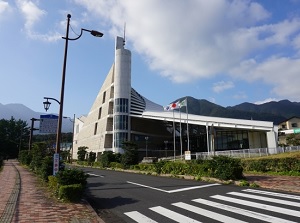
Yakushima Environmental Culture Village Center
Old Yakusugi in Shiratani-Unsuikyo
Miyanoura is the main village to travel around the island and there is the ferry port.
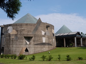
There is Yakushima Environmental Culture Village Center (屋久島環境文化村センター).
We can learn Yakushima by screen images and exhibits before touring around Yakushima.
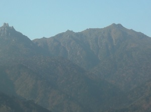
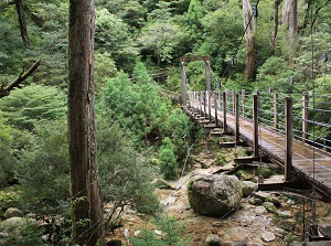
Shiratani-Unsuikyo (白谷雲水峡)
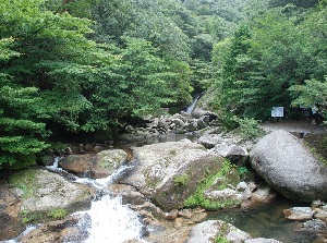
Shiratani-Unsuikyo in Yakushima
Yayoi-sugi in Shiratani-Unsuikyo
Shiratani-Unsuikyo is a ravine formed by Shiratani River.
It is located about 11 km south of Miyanoura.
By route bus, it takes about 30 minutes from Miyanoura.
The popular ravine is the area preserving the old-growth forest.
There is Yayoi-sugi (弥生杉) near the entrance of the ravine located about 620 meters above sea level.
It is a Yakusugi about 3,000 years old and about 26 meters tall.
A few walking trails are set up in the ravine, and the longest route is over 5 km long.
And the route is set up at the altitude of 600 to 1,000 meters.
It takes an hour to see only Yayoi-sugi.
It takes 3 to 5 hours to walk around the ravine.
Wilson stump (ウィルソン株)
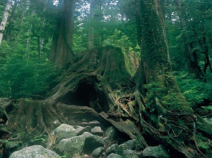
Wilson-kabu
Photo: Kagoshima Prefectural Visitors Bureau
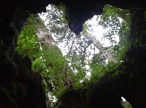
Heart-shaped window of Wilson-kabu
Wilson stump ("Wilson-kabu" in Japanese) is a huge stump of Yakusugi at an altitude of 1,030 meters.
It is said that the tree was cut down to construct Osaka Castle in 1586.
At that time, it was about 3,000 years old.
Ernest Henry Wilson (1876-1930, an American botanist) visited Japan in 1914, then he introduced this stump to the world.
The stump has a large hollow, and a small shrine is set up in the hollow.
When you look up at the sky in the hollow, you can find the heart-shaped window.
It is on the climbing route to Jômon-sugi.
It is located about 7 km from Arakawa starting point ("Arakawa Tozanguchi" in Japanese) where visitors reach from Anbou by route bus.
It takes about 3.5 hours from Arakawa starting point on foot.
And it is located about 7 km from Shiratani-Unsuikyo.
But it takes about 6 hours from Arakawa on foot.
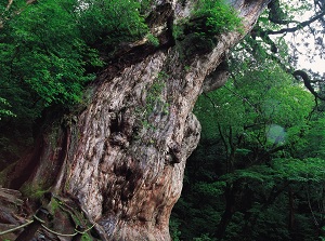
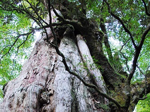
Jômon-sugi (縄文杉)
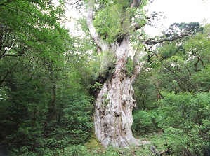
Jomon-sugi in Yakushima
Photo: Kyushu Tourism Promotion Organization
Trunk of Jomon-sugi
Photo: Kagoshima Prefectural Visitors Bureau
Jômon-sugi is the oldest Yakusugi located at an altitude of 1,300 meters, and is the symbol of Yakushima.
It is located about 1.5 km west of Wilson stump, and it takes about 1 hour on foot.
Jômon-sugi is estimated to be 2,600 to 7,200 years old.
Estimating is difficult, so some values have ever been sumbitted.
"Jômon" is one of the names of primitive ages in Japan.
The period startred around 16,000 years ago and ended about 3,000 years ago.
This tree sprouted in the period.
It is about 30 meters tall, and has a trunk 16 meters around.
Not to damage the roots, we must see the tree from the observatory.
Eastern forest from Anbou
Yakusugi Shizenkan
Photo: Kyushu Tourism Promotion Organization
Walking trail on former railway in Yakushima
Anbou is a village on the east coast of the island, and is about 18 km from Miyanoura.
By route bus, it takes about 40 minutes.
The entrance to the east side of the island is Yakusugi Shizenkan (屋久杉自然館, Yakusugi Museum).
It is the museum introducing Yakusugi as a tree in Yakushima, its history and the utilizaton.
It is located about 4 km west of Anbou village and at about 200 meters above sea level.
From Anbou, route bus is operated a few times a day. (About 6 minutes)
There is Yakushima World Heritage Conservation Center (屋久島世界遺産センター) near Yakusugi Shizenkan.
It is a museum introducing Yakushima as a World Heritage site.
From Yakusugi Shizenkan, two routes are set up by route bus.
One is the route to the previously mentioned Jômon-sugi.
The bus goes to Arakawa starting point at about 600 meters above sea level.
It takes about 35 minutes, and the visitors start to walk from there to Jômon-sugi.
Another is the route to Kigen-sugi which is also a popular old Yakusugi.
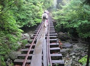
By the way, there was a railway for transporting cut timber from a forest.
The visitors walk on the railway in most sections on the routes.
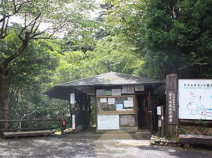
Yakusugi Land in Yakushima
Photo: Kyushu Tourism Promotion Organization
Kigen-sugi
Photo: Kagoshima Prefectural Visitors Bureau
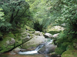
Yakusugi Land (ヤクスギランド)
Yakusugi Land is the forest located about 12 km west of Yakusugi Shizenkan.
The forest is located at an altitude of around 1,000 meters.
It takes 33 minutes from Yakusugi Shizenkan by route bus.
The forest is designated as a Natural Recreation Forest by the Forestry Agency.
It is about 270 hectares in area and has many Yakusugi.
Four trekking routes (30, 50, 80 and 150 minutes) are set up.
You can enjoy the forest of old Yakusigi very easily.
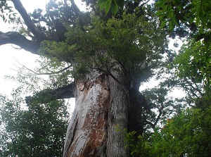
Kigen-sugi (紀元杉)
Kigen-sugi is a Yakusugi as old as Jomon-sugi.
It is located about 6 km west of Yakusugi Land and at an altitude of around 1,230 meters.
It is said that the tree is about 3,000 years old.
The height is about 19 meters, and it has a trunk about 8 meters around.
By route bus, it takes 20 minutes from Yakusugi Land.
The bus is operated only two times a day (around 10:00, around 14:00).
The bus returns to Yakusugi Shizenkan in 18 minutes, so you shouldn't miss the bus.
Along the coastline of the island
Northern coast from Miyanoura
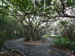
Shitogo Gajumaru Park
Photo: Kyushu Tourism Promotion Organization
Nagata Inaka-hama
Photo: Kyushu Tourism Promotion Organization
The route bus is operated from Miyanoura to Nagata village on the northwest part of the island.
Shitogo Gajumaru Park (志戸子ガジュマル公園) is in Shitogo village located about 6 km west of Miyanoura.
It takes 16 minutes from Miyanoura by route bus.
"Gajumaru" means "banyan" in English, and is a tropical tree.
In this park, wild banyans form a deep forest and ther trees are 200 to 500 years old.
The park is the northern limit of banyan.
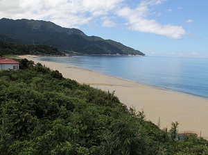
Nagata Inaka-hama (永田いなか浜) is a sand beach about 0.8 km long located about 1 km north of Nagata village and about 13 km southwest of Shitogo village.
It takes 35 minutes from Miyanoura by route bus.
This beach is one of few sand beach in the steep island.
It is the Japan's greatest place where turtles in the Pacific Ocean spawn every year.
So, this beach is registered under the Ramsar Convention.
The peak of spawning is from June to July.
Southern coast from Anbou
Toroki Falls
Photo: Kyushu Tourism Promotion Organization
Senpiro Falls
Photo: Kagoshima Prefectural Visitors Bureau
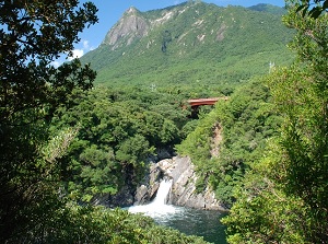
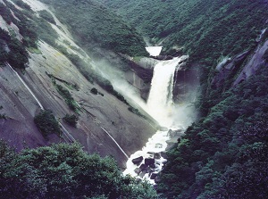
Tainoko river flows to the southeast and there is unique Torôki Falls at the mouth of the river.
It is located about 10 km southwest of Anbou village.
It takes 15 minutes from Anbou by route bus. (The bus stop is "Botanical Research Park".)
The water falls down into sea directly.
Such waterfalls are only this and Kamuiwakka waterfall in Shiretoko Peninsula in Hokkaido.
But the height is only 6 meters and it is in a small cove.
So we can see it at the observatory on the opposite side.
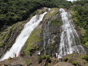
There is Senpiro Falls (千尋の滝) about 2 km upstream of Torôki Falls
The water of a river falls down on a huge monolith of granite.
The height is about 60 meters.
Hirauchi kaichu-onsen
Photo: Kyushu Tourism Promotion Organization
Oko Falls
Photo: Kyushu Tourism Promotion Organization
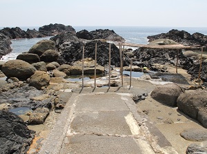
Hirauchi seaside hot spring (平内海中温泉, "Hirauchi kaichu-onsen" in Japanese) is located about 10 km west of Torôki Falls.
It takes 41 minutes from Anbou by route bus.
It is a seaside hot spring on the south coast of the island.
Hot spring is gushing on the edge of the rocky shore, and we can take a bath only for two hours around low tide.
When the tide comes in, it goes under the water.
Of course, men and women must bathe together, and there is no undressing room.
In addition, you must bathe naked.
Yakushima Fruits Garden is a forest park with many plants of tropical fruits.
It is located about 7 km west-northwest of Hirauchi seaside hot spring.
It takes 50 minutes from Anbou by route bus. (The bus stop is "Nakama".)
We can see the common tropical fruits in the natural condition.
Of course, after tour of the garden, we can enjoy the fruits harvested in the garden.
Ôko Falls (大川の滝) is located about 6 km north of Yakushima Fruits Garden.
It is the Yakushima's largest waterfall located near the southwest coast.
The height is 88 meters, and much water fall down strongly.
We can go to close to waterfall basin.
Only a few rote buses are operated to this waterfall.
It takes about an hour from Anbou.
Seibu-Rindô (西部林道)
Seibu-Rindo in Yakushima
Photo: Kagoshima Prefectural Visitors Bureau
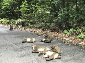
Monkeys on Seibu-Rindo
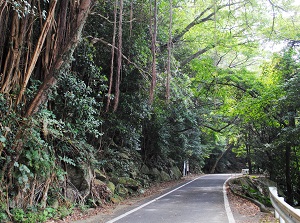
Seibu-Rindô is a road in the western coast of the island.
It is about 15 km long running through the area of the World Heritage Site along the western coast.
Large car is not allowed to run on this road, so no route bus runs on the route.
Because small car is OK, visitors can run by rental car or rental bicycle.
Evergreen broadleaf forests spread along the road, and monkeys and deer appear on the road often.
How to get here
By airplane, about 35 minutes from Kagoshima Airport.
From the airport, by route bus, 20 minutes to Miyanoura, 20 minutes to Anbou.
By high-speed ship, about 2.5 to 3 hours from Kagoshima Port.
Some ships come to Miyanoura, and the others come to Anbou.