Ito Onsen [伊東]
Ito city
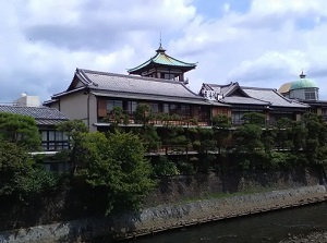
Old high-class ryokan in Ito
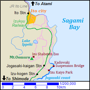
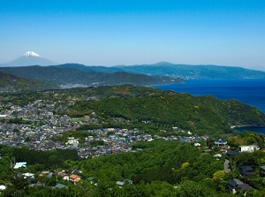
Ito is a city located in the northeast part of Izu Peninsula and about 15 km south of Atami.
"O" in "Ito" is pronounced long, so it is read as "Itô".
Ito is exactly a hot spring resort city.
There are many hot springs in the center of the city, and there are a lot of hotels and ryokans in the area.
And there are ten public bathhouses.
"Shichifukujin" are "seven gods of good luck" in Japan, and a stone statue of them stands in front of each bathhouse.
The bathhouse is open from around 14:00 to 22:00.
The western and southern area of the city is hilly.
There is Mount Oomuro (大室山) about 8 km south of the center of Ito city.
When it was an active volcano in the ancient times, the lava formed the hilly shape of the land.
Generally the area is called Izu-kogen (伊豆高原).
It has an altutude of 50 to 250 meters.
Izu-kogen had been developed as a resort villa area since the 1960s.
So many villas and resort facilities are dotted.
And, small art galleries and museums are also dotted in this area.
JR Ito Line leads to Ito city from Atami.
And Izukyu Railway runs from Ito station through Izu-kogen to Shimoda.
Many trains are operated from Atami through Ito and Izu-kogen to Shimoda.
And JR limited express come from Tokyo.
Mount Oomuro (大室山)
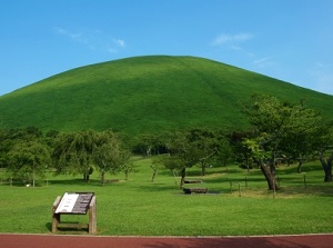
Mount Oomuro
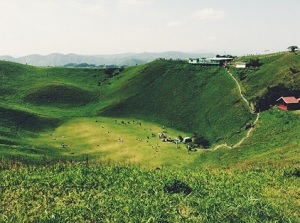
Crater of Mount Oomuro
Mount Oomuro is an inactive volcano, and is located about 8 km south of central Ito city.
The altitude is 580 meters and the mountain has a conical shape.
The last eruption was about 4,000 to 5,000 years ago, and it is quite inactive now.
The whole mountain slope is covered with grass and there is no tree.
A lift leads to the top from the northern foot of the mountain.
There is a crater about 300 meters in diameter on the top of the mountain.
The edge of the crater is a good observatory and there is a walking trail about 1 km long rounding the crater.
And, there are an archery facility for beginner and Sengen Shrine in the bottom of the crater.
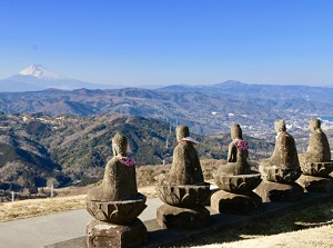
Mt.Fuji & Buddha statues from Mt. Oomuro
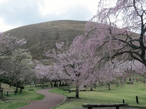
Sakura-no-sato
At the northwest foot of the mountain, there is Sakura-no-sato (さくらの里).
About 1,500 cherry trees are planted in the wide grass field without other trees.
From late March to early April, main cherry trees are in full bloom.
In addition, from autumn to early May, various kinds of cherry trees bloom.
Izu Shaboten Zoo (伊豆シャボテン動物公園)
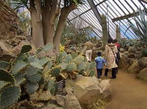
Cactuses in Izu Shaboten Zoo
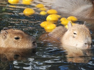
Capybaras in hot spring
Izu Shaboten Zoo is a theme park of cactus and lovely animal.
It is located at the north foot of Mount Oomuro.
"Cactus" is called "Saboten" in Japanese today, but the word "Shaboten" also had been used decades ago.
Literally, this park displays about 1,500 kinds of cactuses in the world.
Additionally many lovely animals such as squirrel monkey, capybara, peacock are unconfined in this park.
Especially, capybaras soaking in a hot spring are popular in winter.
Lake Ippeki (一碧湖)
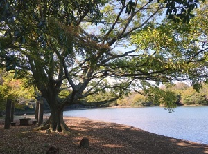
Lake Ippeki
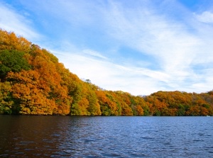
Lake Ippeki in autumn
Lake Ippeki ("Ippekiko" in Japanese) is a small lake located about 3 km north of Mount Oomuro.
It is a crater lake formed about 100 thousand years ago, then the lava of Mount Oomuro dammed the southeast part of the lake about 4,000 to 5,000 years ago.
The lake is a round lake about 500 meters in diameter.
It is surrounded by beautiful forests, and a few hotels and an art gallery are around the lake.
Jogasaki coast (城ヶ崎海岸)
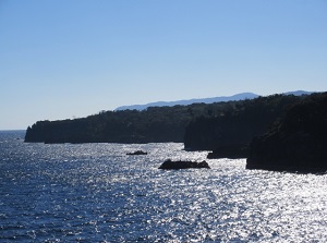
Jogasaki coast
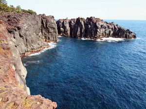
Jogasaki coast
Jogasaki is the rocky coast located to the southeast of Mount Oomuro.
"O" is the word is pronounced long, so it is read as "Jôgasaki kaigan" in Japanese.
The north edge of the coast is located about 12 km south of Ito city and the length is about 5 km.
The lava by the eruption of Mount Oomuro flew down and reached this coast.
Then this steep and indented coastline was formed.
Along the winding coastline, a walking trail with ups and downs is set up and the total length is about 9 km.
Izukyu Railway runs 0.5 to 1.5 km inland, and Futo, Jogasaki-kaigan and Izu-kogen stations are the entrance to the walking trail.
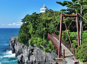
Kadowaki Suspension Bridge
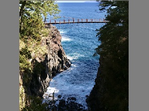
Kadowaki Suspension Bridge
Kadowaki Suspension Bridge (門脇吊橋) is a popular spot of this coast.
It is across the small cove and the length is 48 meters.
Wild sea waves beat the rocky cliffs under the bridge.
It is located about 1.8 km from Jogasaki-kaigan station.
And there is Izu Kaiyo Park (伊豆海洋公園) about 0.8 km south of Kadowaki Suspension Bridge.
It is a park with a facility for diving by the coast.
How to get here
To Ito station, by JR limited express, about 20 to 25 minutes from Atami, about 1 hour and 40 to 45 minutes from Tokyo.
Or, by local train, about 22 to 28 minutes from Atami.
From Ito station, by route bus for Shaboten-koen, about 27 minutes to Lake Ippeki, about 40 minutes to Izu Shaboten Park terminal.
To Jogasaki coast, get on Izukyu Railway.
By local train, from Ito, 15 minutes to Futo, 18 minutes to Jogasaki-kaigan, 21 minutes to Izu-kogen.
And the route buses connecting Shaboten Park, Izu Kaiyo Park, Jogasaki-kaigan station and Izu-kogen station.