Ishigaki Island [石垣島]
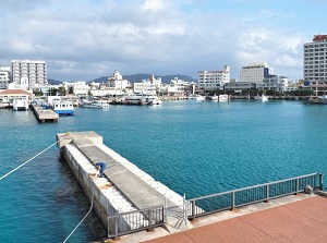
Ishigaki Port
Kabira Bay in Ishigaki Island
Ishigaki Island ("Ishigakijima" in Japanese) is located about 420 km southwest of Okinawa Island and about 120 km west-southwest of Miyako Island.
Taiwan is about 270 km west of this island, so it is closer to a foreign country rather than the prefectual capital.
Around Ishigaki Island, there are Iriomote Island and some other small islands.
Generally, the group of these islands is called Yaeyama Islands (八重山諸島).
Ishigaki Island has the largest population of them and is the center of Yaeyama area.
Ishigaki Island is the third largest island in Okinawa Prefecture, after Okinawa Island and Iriomote Island.
This island is shaped like a ladle.
The main part of the island is about 15 km from north to south and about 20 lm from east to west.
And a long and narrow peninsula about 20 km long expands to the northeast.
Mount Omoto (於茂登岳, Omotodake, 526 m) is in the center of the island, and it is the highest mountain in Okinawa Prefecture.
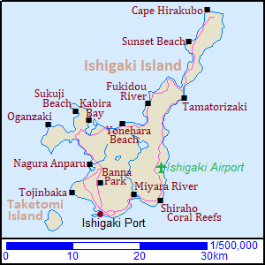
Sugarcane field in Ishigaki Island
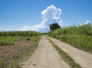
Scenery of a coast in Ishigaki Island
Ishigaki district on the south coast is the largest town, and is the only densely-populated area in Yaeyama Islands.
There is Ishigaki Port where the ferries to the other islands depart near the center of the town.
And Ishigaki Airport is located about 15 km northeast of the district.
This island is surrounded by coral reefs, and has many beautiful beaches.
It has beautiful nature richly, so one third part of the island is in a national park.
We can enjoy diving and snorkeling.
There are some resort hotels, and many small minshuku (Japansese style inn) or resort inns in this island.
Route bus is operated in the island.
The buses run from Ishigaki district to the various places in the island.
The buses are operated relatively frequently around Ishigaki district.
But they are operated only some times a day in the other areas.
You can rent a car, motorbike or bicycle, or use a sightseeing taxi.
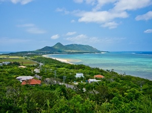
Southern part of Ishigaki Island
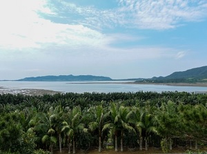
Canoe tour in Miyara River
Shiraho coast in Ishigaki Island
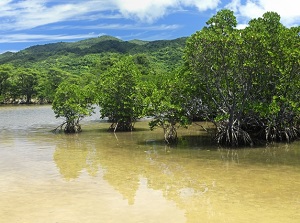
Miyara River (宮良川) is the largest river in Ishigaki Island, and it flows to the south through the island.
The mouth is located about 7 km east-northeast of the center of Ishigaki district.
Thick mangrove forests spread along the river for about 1.5 kilometers.
It is said that the forests of mangrove is the largest in Japan.
We can see the forests on the bridge of the national road, and canoe tours on the river are conducted.
The nearest bus stop is Miyara-bashi (22 minutes from Bus terminal near Ishigaki port).
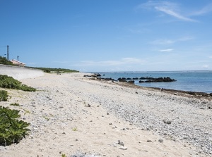
There is Shiraho Coral Reefs (白保サンゴ礁, Shiraho Sangoshô) along the southeast coast of the island.
There is the sand beach, and great coral reefs are in the sea.
The coral reefs are about 10 km long and about 1 km wide.
More than 70 species of coral are known in this coast, and very good condition has been kept.
Especially, it is said that the great community of blue coral is the largest in the Northern hemisphere.
The nearest bus stop is Shiraho (28 minutes from Bus terminal near Ishigaki port).
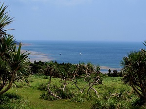
View from Banna Park
Shiraho coast in Ishigaki Island
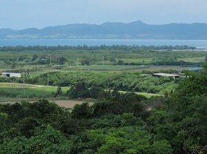
Banna Park (バンナ公園) is a park on Mount Banna 230 meters high.
It is located about 4 km north of the center of Ishigaki district.
There are a few observatories in the park, and we can enjoy the good view of southern Ishigaki Island and sea.
The nearest bus stop is Yaemori-no-tou (13 minutes from Bus terminal near Ishigaki port).
But it is operated only a few times a day.
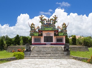
There is a unique spot located about 6 km northwest of the center of Ishigaki district.
It is called Tôjinbaka (唐人墓) and is a cemetery of Chinese people by the sea.
In 1852, American ship left from Xiamen in southern China.
About 400 Chinese workers (Coolie) were on board.
Because they were treated very hard on board, they raised a riot at last.
The ship went aground near Ishigaki Island, then 380 Chinese Coolies escaped into the island.
The Ishigaki islanders provided them with housing.
But the American and British navies came to this island twice.
And they searched out the fugitives and killed many of them.
After that, by international contact, Ryukyu Kingdom sent the 172 surviving Chinese Coolies back to China.
And the tombs for dead 128 Chinese were built here and there.
"Tôjin" is an old Japanese word meaning "Chinese people" and "baka" changed from "haka" by connecting words means "cemetery".
The cemetery was constructed to console the people totally in 1971.
It is a Chinese-style monument with gorgeous decorations of dragon.
Western part of Ishigaki Island
Mangrove forests of Nagura Anparu
Cape Oganzaki
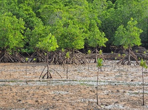
Nagura Anparu (名蔵アンパル) is a wetland along the west coast located about 8 km north of Ishigaki district.
It is surrounded by sandbanks about 1.5 km long at the mouth of Nagura River.
Mangrove forests, tropical forests, various grasses grow in and around the wetland.
Various fish and aquatic organism are in the water.
This wetland is inscribed as a registered wetland under the Ramsar Convention.
Cape Oganzaki (御神崎) is a cape on the western peninsula.
It is located about 17 km northwest central Ishigaki district.
The sea around the cape is deep and has no coral reef, so the sea is rough.
We can see the beautiful sunset.
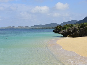
Sukuji Beach (底地海水浴場) is beautiful beach on the western coast, and is located about 5 km east-northeast of Cape Oganzaki.
The beach is filled with white sands and the sea is shallow.
The view of sunset is beautiful.
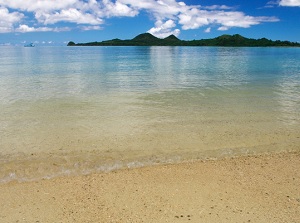
Sukuji Beach
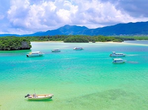
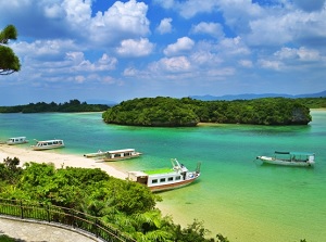
Kabira Bay
Kabira Bay (川平湾) is the most popular and beautiful beach in Ishigaki Island.
It is located about 18 km north of the center of Ishigaki district.
The bay is about 2 km from north to south and about 1 km in width.
Some islands blocks the bay except a few waterways to the open sea.
The scenery is very good, and the changing color of the sea is beautiful.
But the current in the bay is strong, so it is forbidden to swim.
Instead, we can enjoy the sea by glass-bottom boat.
Route bus is operated from from Bus terminal near Ishigaki port, and it takes 45 minutes.
Yonehara Beach (米原ビーチ) is also a beautiful beach, and is located about 8 km east of Kabira Bay.
The beach of white sand spreads and there are the coral reefs in the sea.
So it is a popular snorkeling spot.
Southern peninsula in the island
Fukidou River
Tamatorizaki
Fukidou River (吹通川) is a river located about 25 km north of Ishigaki district and flows into the sea on the west side of the island.
There are thick forests and mudlands along the river, and there are the large mangrove forests after Miyara River.
Canoe tours on the river are conducted.
Tamatorizaki (玉取崎) is a cape on the east side of the peninsula and is located about 28 km north-northeast of Ishigaki district.
There is an observatory around the cape and we can see the long peninsula and beautiful sea.
Many hibiscus flowers bloom around the cape throughout the year.
Sunset Beach is a beautiful beach located about 10 km north of Tamatorizaki.
It is a beach owned by a company of tourist facilities, so there is a charge for enjoying the beach.
Sunset Beach in Ishigaki Island
Photo by Okinawa Convention & Visitors Bureau
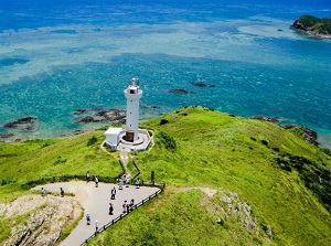
Cape Hirakubo
Cape Hirakubo (平久保崎) is the north tip of Ishigaki Island.
It is located about 45 km north-northeast of Ishigaki district.
A white lighthouse stands on the tip of the cape, and grass fields spread on the cape.
How to get here
By airplane, about an hour from Naha Airport.